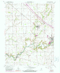
1956 Map of Waldron
USGS Topo · Published 1983About this map
Flatrock River carves a winding path through this central Indiana landscape, defining the topography between Shelby, Rush, and Decatur counties. During the mid-twentieth century, the region maintained a dense network of rural infrastructure, from the St Vincent Sch in the north to the Wesley Chapel and Pleasant Hill Ch further south. The Conrail line serves as a central transportation spine, linking the larger settlements of Waldron and Saint Paul.
Find a feature on this map
43 named features on this map. Tap any name to fly to it.
Don’t see what you’re looking for? This feature index may not catch every label — zoom into the map to look around manually.
Map Details
Editions of this 1956 Waldron Map
5 editions found
Other maps of this area

1942 · Columbus
USGS Topo · 1:125,000

1947 · Hope
USGS Topo · 1:24,000

1948 · Hope
USGS Topo · 1:24,000

1948 · Lewis Creek
USGS Topo · 1:24,000

1950 · Edinburg
USGS Topo · 1:62,500

1953 · Shelbyville
USGS Topo · 1:24,000

1953 · Cincinnati
USGS Topo · 1:250,000

1956 · Waldron
USGS Topo · 1:24,000

1956 · Rays Crossing
USGS Topo · 1:24,000

1957 · Cincinnati
USGS Topo · 1:250,000