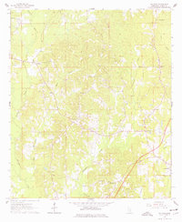
1963 Map of Waldrup
USGS Topo · Published 1977About this map
Waldrup and the western edge of Heidelberg anchor this rural landscape in the early 1960s, defined by the winding paths of Tallahala Creek, Tallahatta Creek, and Bogue Homo. The map reveals a deeply religious community structure, dotted with numerous country churches such as Philadelphia Ch, Old Ebenezer Ch, and Oakbowery Ch. The terrain is characterized by dispersed family homes and small-scale extractive operations, evidenced by several Claypit sites near Ealiah Creek.
Find a feature on this map
23 named features on this map. Tap any name to fly to it.
Don’t see what you’re looking for? This feature index may not catch every label — zoom into the map to look around manually.
Map Details
Editions of this 1963 Waldrup Map
3 editions found
Other maps of this area

1953 · Hattiesburg
USGS Topo · 1:250,000

1953 · Meridian
USGS Topo · 1:250,000

1957 · Meridian
USGS Topo · 1:250,000

1957 · Enterprise
USGS Topo · 1:62,500

1958 · Hattiesburg
USGS Topo · 1:250,000

1963 · Waldrup
USGS Topo · 1:24,000

1963 · Heidelberg
USGS Topo · 1:24,000

1964 · Heidelberg SW
USGS Topo · 1:24,000

1964 · Moss
USGS Topo · 1:24,000

1964 · Sandersville
USGS Topo · 1:24,000