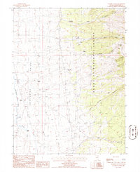
1985 Map of Walker Canyon
USGS Topo · Published 1986About this map
Huntington Valley serves as the focal point for this 1980s landscape, where the flat valley floor meets the rising terrain of the Humboldt National Forest. The map documents a sparsely settled ranching and mining environment, anchored by the Juarts Ranch near the mouth of Walker Canyon. Water sources are the lifeblood of this arid region, with numerous named springs such as Pete Holm Spring, Aurora Spring, and Defue Spring providing critical reference points for land use and navigation. The network of drainage features, including Huntington Creek and Sestanouich Creek, illustrates the complex topography of the canyon systems. Evidence of historical mineral exploration is found in several identified prospects and mining sites tucked into the hillsides, reflecting the ongoing search for resources in this corner of White Pine County.
Find a feature on this map
21 named features on this map. Tap any name to fly to it.
Don’t see what you’re looking for? This feature index may not catch every label — zoom into the map to look around manually.
Map Details
Editions of this 1985 Walker Canyon Map
This is the sole edition of this map. No revisions or reprints were ever made.
Other maps of this area

1934 · Jiggs
USGS Topo · 1:125,000

1937 · Jiggs
USGS Topo · 1:125,000

1955 · Elko
USGS Topo · 1:250,000

1956 · Ely
USGS Topo · 1:250,000

1957 · Diamond Springs
USGS Topo · 1:62,500

1957 · Cold Creek Ranch
USGS Topo · 1:62,500

1958 · Elko
USGS Topo · 1:250,000

1959 · Ely
USGS Topo · 1:250,000

1959 · Railroad Pass
USGS Topo · 1:62,500

1959 · Sherman Mtn
USGS Topo · 1:62,500