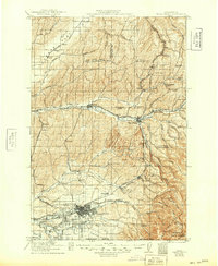
1921 Map of Walla Walla
USGS Topo · Published 1949About this map
Walla Walla is depicted here as a thriving agricultural and rail hub at the foothills of the Blue Mountains shortly after the turn of the century. The city layout is highly detailed, showing the State Penitentiary on its northern edge and the Whitman Monument to the west, commemorating local missionary history. The landscape is defined by the transition from the broad, arid Eureka Flat in the northwest to the complex drainage systems of the Touchet River and Mill Creek. This 1916 and 1919 survey records a period when the region was densely punctuated by small rural schoolhouses, such as Pettijohn School and Bourgeois School, and interconnected by the Northern Pacific Railway and the Oregon Washington Railroad and Navigation Company, illustrating the peak of the inland empire's railroad-driven wheat economy.
Find a feature on this map
109 named features on this map. Tap any name to fly to it.
Don’t see what you’re looking for? This feature index may not catch every label — zoom into the map to look around manually.
Map Details
Editions of this 1921 Walla Walla Map
2 editions found
Other maps of this area

1915 · Wallulah
USGS Topo · 1:96,000

1916 · Connell
USGS Topo · 1:125,000

1918 · Connell
USGS Topo · 1:125,000

1918 · Wallula
USGS Topo · 1:125,000

1919 · Walla Walla
USGS Topo · 1:125,000

1921 · Walla Walla
USGS Topo · 1:125,000

1935 · Pendleton
USGS Topo · 1:125,000

1937 · Pomeroy
USGS Topo · 1:96,000

1942 · Pomeroy
USGS Topo · 1:125,000

1948 · Starbuck
USGS Topo · 1:62,500