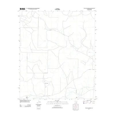
2013 Map of Wallace Draw
USGS Topo · Published 2013About this map
Middle Concho River traverses the southern edge of this West Texas landscape, where the seasonal drainage of Wallace Draw and Big Hollow Draw define the local topography. This early 21st-century survey of Irion County illustrates the remote ranching infrastructure characteristic of the Edwards Plateau region. The map identifies the Sugg Ranch and a network of specialized local thoroughfares, such as Cattle Guard 8 Rd and Andy Suggs Rd, which connect isolated parcels across the semi-arid terrain. The winding path of Dry Cr dominates the northern half of the sheet, while evocative place names like Hell Hole Rd hint at the challenging environment encountered by early settlers and land managers in this part of the Concho Valley watershed.
Find a feature on this map
11 named features on this map. Tap any name to fly to it.
Don’t see what you’re looking for? This feature index may not catch every label — zoom into the map to look around manually.
Map Details
Editions of this 2013 Wallace Draw Map
This is the sole edition of this map. No revisions or reprints were ever made.
Other maps of this area

1895 · Sherwood
USGS Topo · 1:125,000

1921 · Ketchum Mountain
USGS Topo · 1:62,500

1923 · Ketchum Mountain
USGS Topo · 1:62,500

1954 · San Angelo
USGS Topo · 1:250,000

1958 · San Angelo
USGS Topo · 1:250,000

1965 · San Angelo
USGS Topo · 1:250,000

1972 · Arden
USGS Topo · 1:24,000

1972 · Wallace Draw
USGS Topo · 1:24,000
1972 · Mertzon SW
USGS Topo · 1:24,000

1972 · Dog Creek SW
USGS Topo · 1:24,000