
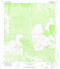
1972 Map of Arden
USGS Topo · Published 1974About this map
Arden serves as a central point of reference in this West Texas landscape, defined by the winding course of the Middle Concho River and several ephemeral watercourses. This early 1970s survey captures a rural environment where infrastructure like a prominent Pipeline and multiple Gravel Pits cut across the natural drainages of West Rocky Creek and Dry Rocky Creek. The presence of the Arden Cem and the small settlement of Mertz toward the south provides essential landmarks for genealogists and local historians tracing families in Irion County. The terrain is characterized by dissected plateaus and draws, most notably Dry Creek, illustrating the complex hydrological network that defines this portion of the Edwards Plateau. The map reflects a moment in time when resource extraction and transportation infrastructure began to integrate more deeply into traditional ranching territories.
Find a feature on this map
9 named features on this map. Tap any name to fly to it.
Don’t see what you’re looking for? This feature index may not catch every label — zoom into the map to look around manually.
Map Details
Editions of this 1972 Arden Map
This is the sole edition of this map. No revisions or reprints were ever made.
Other maps of this area

1895 · Sherwood
USGS Topo · 1:125,000

1928 · Tankersly
USGS Topo · 1:62,500

1954 · San Angelo
USGS Topo · 1:250,000

1957 · Carlsbad
USGS Topo · 1:62,500

1957 · Knickerbocker
USGS Topo · 1:62,500

1958 · San Angelo
USGS Topo · 1:250,000

1965 · San Angelo
USGS Topo · 1:250,000

1972 · Wallace Draw
USGS Topo · 1:24,000
1972 · Mertzon SW
USGS Topo · 1:24,000

1972 · Dog Creek SW
USGS Topo · 1:24,000