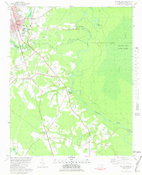
1981 Map of Wallace East
USGS Topo · Published 1981About this map
The Northeast Cape Fear River winds through a landscape of dense wetlands and small agricultural settlements in the early 1980s. To the east, the vast Angola Swamp and Angola Bay Game Land dominate the terrain, creating a natural boundary for the development along the Seaboard Coast Line railroad. This rail corridor serves as the backbone for several rural communities, including Willard, Washington, and Watha. In the northwest, Wallace appears as a center of local activity, containing the Municipal Building and Armory. A distinct geological feature, The Horseshoe, marks a sharp bend in the river, while smaller watercourses like Little Rockfish Creek and Sawyer Creek drain the surrounding fields. Local heritage is preserved in sites such as Poston Ch and the Riverview Memorial Park (Cemetery), providing valuable touchpoints for genealogical research in this part of Pender County.
Find a feature on this map
31 named features on this map. Tap any name to fly to it.
Don’t see what you’re looking for? This feature index may not catch every label — zoom into the map to look around manually.
Map Details
Editions of this 1981 Wallace East Map
This is the sole edition of this map. No revisions or reprints were ever made.
Other maps of this area

1942 · Burgaw
USGS Topo · 1:62,500

1943 · Kenansville
USGS Topo · 1:62,500

1948 · Kenansville
USGS Topo · 1:62,500

1953 · Florence
USGS Topo · 1:250,000

1953 · Beaufort
USGS Topo · 1:250,000

1954 · Florence
USGS Topo · 1:250,000

1954 · Beaufort
USGS Topo · 1:250,000

1955 · Atkinson
USGS Topo · 1:62,500

1962 · Rose Hill
USGS Topo · 1:62,500

1972 · Beaufort
USGS Topo · 1:250,000