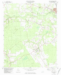
1984 Map of Wallace West
USGS Topo · Published 1984About this map
Penderlea stands as a focal point in this 1980s landscape, characterized by the planned layout of a New Deal-era agricultural community. The map details the transition between Duplin and Pender counties, where the land is deeply carved by drainage systems like Rockfish Creek and Moores Creek. Evidence of earlier transport networks is visible in the Old Railroad Grade and the active Seaboard Coast Line corridor near Wallace. Local genealogy is well-supported by numerous family-named landmarks and rural congregations, including Alderman Cem, Newkirk Chapel, and Antioch Ch. The landscape also reveals small-scale infrastructure like Henderson Field and the Gaging Station on Rockfish Creek, illustrating the mid-century intersection of rural agriculture and regional development.
Find a feature on this map
37 named features on this map. Tap any name to fly to it.
Don’t see what you’re looking for? This feature index may not catch every label — zoom into the map to look around manually.
Map Details
Editions of this 1984 Wallace West Map
This is the sole edition of this map. No revisions or reprints were ever made.
Other maps of this area

1942 · Burgaw
USGS Topo · 1:62,500

1943 · Kenansville
USGS Topo · 1:62,500

1948 · Kenansville
USGS Topo · 1:62,500

1953 · Florence
USGS Topo · 1:250,000

1953 · Beaufort
USGS Topo · 1:250,000

1954 · Florence
USGS Topo · 1:250,000

1954 · Beaufort
USGS Topo · 1:250,000

1955 · Atkinson
USGS Topo · 1:62,500

1962 · Rose Hill
USGS Topo · 1:62,500

1972 · Beaufort
USGS Topo · 1:250,000