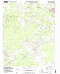
1997 Map of Wallace West
USGS Topo · Published 2001About this map
Penderlea stands as a focal point in this coastal plain landscape, characterized by the intricate drainage networks of Rockfish Creek and Sills Creek. The map reveals a rural community structure deeply tied to its land and faith, evidenced by numerous small congregations such as Corinth Ch, Rapture Ch, and Newkirk Chapel. Genealogists will find significant value in the documentation of family-named landmarks and burial grounds, including the Alderman Cem and Powers Cem, which anchor the history of local lineage to specific plots of ground.
Find a feature on this map
36 named features on this map. Tap any name to fly to it.
Don’t see what you’re looking for? This feature index may not catch every label — zoom into the map to look around manually.
Map Details
Editions of this 1997 Wallace West Map
This is the sole edition of this map. No revisions or reprints were ever made.
Other maps of this area

1942 · Burgaw
USGS Topo · 1:62,500

1943 · Kenansville
USGS Topo · 1:62,500

1948 · Kenansville
USGS Topo · 1:62,500

1953 · Florence
USGS Topo · 1:250,000

1953 · Beaufort
USGS Topo · 1:250,000

1954 · Florence
USGS Topo · 1:250,000

1954 · Beaufort
USGS Topo · 1:250,000

1955 · Atkinson
USGS Topo · 1:62,500

1962 · Rose Hill
USGS Topo · 1:62,500

1972 · Beaufort
USGS Topo · 1:250,000