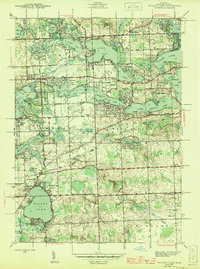
1945 Map of Walled Lake
USGS Topo · Published 1945About this map
Union Lake and the surrounding glacial lake district of Oakland County define the character of this 1940s landscape. Before the post-war suburban expansion reached full momentum, this area was a patchwork of established lakeside settlements like Commerce and Walled Lake alongside emerging recreation sites. The shoreline of Orchard Lake and Cass Lake shows a dense concentration of private leisure developments, including the Orchard Lake Country Club and Beach Haven Golf Course, signaling the region's early transition into a premium residential and resort destination.
Find a feature on this map
92 named features on this map. Tap any name to fly to it.
Don’t see what you’re looking for? This feature index may not catch every label — zoom into the map to look around manually.
Map Details
Editions of this 1945 Walled Lake Map
2 editions found
Other maps of this area

1902 · South Lyon
USGS Topo · 1:62,500

1904 · Ann Arbor
USGS Topo · 1:125,000

1905 · Wayne
USGS Topo · 1:62,500

1906 · South Lyon
USGS Topo · 1:62,500

1907 · Pontiac
USGS Topo · 1:62,500

1908 · Ann Arbor
USGS Topo · 1:125,000

1909 · Milford
USGS Topo · 1:62,500

1912 · Wayne
USGS Topo · 1:62,500

1936 · Wixom
USGS Topo · 1:31,680

1936 · Highland
USGS Topo · 1:31,680
Featured Places
- Farmington Hills, MI
- Waterford Township, MI
- Novi, MI
- West Bloomfield Township, MI
- Commerce Charter Township, MI