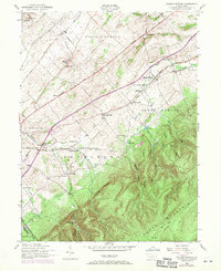
1952 Map of Walnut Bottom
USGS Topo · Published 1970About this map
Yellow Breeches Creek defines the pastoral landscape of the Cumberland Valley in this mid-century survey, where the Reading and Penn Central railroads support a network of rural hubs and schoolhouses. Small settlements like Walnut Bottom and Cleversburg are shown in detail, anchored by community fixtures such as the Newton Township Consolidated School and the South Mountain Chapel. To the south, the terrain shifts abruptly as the valley meets the rise of South Mountain, characterized by a series of distinct hollows like Watery Hollow and Patch Hollow. This interface between industrial transport corridors and the high ridges is further marked by the presence of the Appalachian Trail and the Chambersburg Reservoir, illustrating the dual identity of the region as both a settled agricultural corridor and a protected watershed.
Find a feature on this map
46 named features on this map. Tap any name to fly to it.
Don’t see what you’re looking for? This feature index may not catch every label — zoom into the map to look around manually.
Map Details
Editions of this 1952 Walnut Bottom Map
4 editions found
Other maps of this area

1902 · Chambersburg
USGS Topo · 1:62,500

1909 · Fairfield
USGS Topo · 1:62,500

1919 · Newville
USGS Topo · 1:62,500

1923 · Shippensburg
USGS Topo · 1:62,500

1942 · Hagerstown
USGS Topo · 1:125,000

1942 · Gettysburg
USGS Topo · 1:125,000

1943 · Hagerstown
USGS Topo · 1:125,000

1943 · Chambersburg
USGS Topo · 1:62,500

1943 · Shippensburg
USGS Topo · 1:62,500

1944 · Scotland
USGS Topo · 1:31,680
Featured Places
- Shippensburg, PA
- Southampton Township, PA
- North Newton Township, PA
- West Pennsboro Township, PA
- Southampton Township, PA