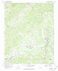
1971 Map of Walnut Cove
USGS Topo · Published 1984About this map
Walnut Cove serves as the primary junction for the Southern and Norfolk and Western railroads, framing the local economy around these rail corridors in the early 1970s. The landscape is defined by the broad valley of Town Fork Creek, which flows westward to join the Dan River in the northeast corner of the sheet. To the southwest, Germanton marks another significant historic cluster, while the surrounding hills are dotted with local landmarks like the South Stokes High Sch and a Fish Hatchery near Buffalo Creek.
Find a feature on this map
49 named features on this map. Tap any name to fly to it.
Don’t see what you’re looking for? This feature index may not catch every label — zoom into the map to look around manually.
Map Details
Editions of this 1971 Walnut Cove Map
3 editions found
Other maps of this area

1951 · Rural Hall
USGS Topo · 1:24,000

1951 · Walkertown
USGS Topo · 1:24,000

1953 · Winston-Salem
USGS Topo · 1:250,000

1955 · Winston-Salem
USGS Topo · 1:250,000

1962 · Winston-Salem
USGS Topo · 1:250,000

1964 · Hanging Rock
USGS Topo · 1:24,000

1964 · King
USGS Topo · 1:24,000

1969 · Belews Creek
USGS Topo · 1:24,000
1971 · Walnut Cove
USGS Topo · 1:24,000
1971 · Belews Lake
USGS Topo · 1:24,000