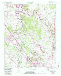
1950 Map of Walterhill
USGS Topo · Published 1984About this map
Stones River National Battlefield anchors the southern portion of this landscape, preserving the site of one of the Civil War's most significant engagements just north of Murfreesboro. The terrain is defined by the winding paths of the East Fork Stones River and West Fork Stones River, which converge as they flow into J Percy Priest Lake. This 1950s-era documentation, updated with 1980s revisions, shows a rural transition as Nashville's suburban reach begins to touch communities like Smyrna and Florence. Along the Seaboard System rail line, small settlements like Wade and Blackman appear alongside scattered country landmarks such as Bethel Sch and Hickory Grove Ch. Several recreation areas, including the Nice Mill Dam Rec Area and Mona Recreation Area, emphasize the river's shift from a transport artery to a center for local leisure.
Find a feature on this map
47 named features on this map. Tap any name to fly to it.
Don’t see what you’re looking for? This feature index may not catch every label — zoom into the map to look around manually.
Map Details
Editions of this 1950 Walterhill Map
5 editions found
Other maps of this area

1903 · Nashville
USGS Topo · 1:125,000

1916 · Murfreesboro
USGS Topo · 1:62,500

1932 · Hermitage
USGS Topo · 1:62,500

1942 · Lebanon
USGS Topo · 1:100,000

1950 · Walterhill
USGS Topo · 1:24,000

1950 · Murfreesboro
USGS Topo · 1:24,000

1952 · La Vergne
USGS Topo · 1:24,000

1956 · Vine
USGS Topo · 1:24,000

1956 · Dillton
USGS Topo · 1:24,000

1956 · Gladeville
USGS Topo · 1:24,000