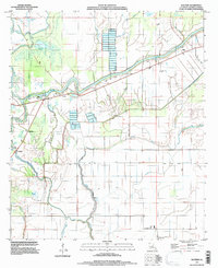
1995 Map of Walters
USGS Topo · Published 1997About this map
The lowlands of Catahoula Parish are defined here by a dense network of waterways and the engineered structures designed to manage them. Small settlements like Walters and Archie are connected by a system of levees, with the Road on Levee providing essential transit through the swampy landscape. The drainage patterns of Hibbs Bayou, Little River, and Crockets Bayou illustrate the complex hydrology of the region, where the Little River Dam and nearby Boat Ramps facilitate both water control and river access.
Find a feature on this map
36 named features on this map. Tap any name to fly to it.
Don’t see what you’re looking for? This feature index may not catch every label — zoom into the map to look around manually.
Map Details
Editions of this 1995 Walters Map
This is the sole edition of this map. No revisions or reprints were ever made.
Other maps of this area

1935 · Tooleys
USGS Topo · 1:62,500

1941 · Manifest
USGS Topo · 1:62,500

1941 · Jena
USGS Topo · 1:62,500

1941 · Buckeye
USGS Topo · 1:62,500

1941 · Tooleys
USGS Topo · 1:62,500

1953 · Alexandria
USGS Topo · 1:250,000

1953 · Natchez
USGS Topo · 1:250,000

1955 · Alexandria
USGS Topo · 1:250,000

1956 · Natchez
USGS Topo · 1:250,000

1958 · Jena
USGS Topo · 1:62,500