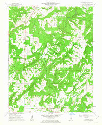
1962 Map of Waltersburg
USGS Topo · Published 1963About this map
The Shawnee National Forest dominates this section of Pope County, where the topography is defined by the winding course of Lusk Creek and its many tributaries like Copperous Branch and Beatty Branch. In the early 1960s, small rural settlements such as Eddyville, Raum, and Waltersburg served as the primary social hubs for the surrounding farmsteads. The area is dotted with numerous country churches, including New Liberty Ch and Mt Zion Ch, which often sit adjacent to family or community burial grounds like Whiteside Cem. A notable landmark of the era is the Raum Lookout Tower, positioned to monitor the dense timberlands of the national forest. The map reveals a landscape where traditional agriculture and forestry met modern infrastructure, shown through the development of State Routes 145 and 146.
Find a feature on this map
37 named features on this map. Tap any name to fly to it.
Don’t see what you’re looking for? This feature index may not catch every label — zoom into the map to look around manually.
Map Details
Editions of this 1962 Waltersburg Map
2 editions found
Other maps of this area

1916 · Golconda
USGS Topo · 1:62,500

1916 · Equality
USGS Topo · 1:62,500

1917 · Brownfield
USGS Topo · 1:62,500

1920 · Goloonda
USGS Topo · 1:48,000

1921 · Golconda
USGS Topo · 1:62,500

1925 · Harrisburg
USGS Topo · 1:62,500

1939 · Harrisburg
USGS Topo · 1:62,500

1949 · Paducah
USGS Topo · 1:250,000

1950 · Paducah
USGS Topo · 1:250,000

1954 · Paducah
USGS Topo · 1:250,000