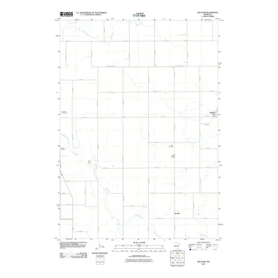
2010 Map of Waltham
USGS Topo · Published 2010About this map
Waltham and the nearby settlement of Mayville anchor this agricultural landscape in Mower County, defined by a rigid grid of township roads and the meandering path of the Cedar River. This 2010 survey illustrates the persistence of rural community hubs, such as the Waltham Post Office, alongside traditional sites of local heritage like Udolpho Cemetery and Saint Michael's Cemetery. The northern section is drained by the Little Cedar River, while the southern reaches follow the winding course of Roberts Creek. While much of the land is partitioned for farming, recreational spaces appear along the waterways, including Brookside Campground and the River Trail Camp, suggesting a modern layer of land use integrated into this established prairie terrain.
Find a feature on this map
42 named features on this map. Tap any name to fly to it.
Don’t see what you’re looking for? This feature index may not catch every label — zoom into the map to look around manually.
Map Details
Editions of this 2010 Waltham Map
This is the sole edition of this map. No revisions or reprints were ever made.
Other maps of this area

1954 · Hayward
USGS Topo · 1:62,500

1954 · Austin
USGS Topo · 1:62,500

1954 · Mason City
USGS Topo · 1:250,000

1957 · Mason City
USGS Topo · 1:250,000

1958 · Mason City
USGS Topo · 1:250,000

1966 · Waltham
USGS Topo · 1:24,000

1966 · Hayfield NW
USGS Topo · 1:24,000
1966 · Hayfield
USGS Topo · 1:24,000

1966 · Sargeant
USGS Topo · 1:24,000

1967 · Bixby
USGS Topo · 1:24,000