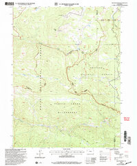
2000 Map of Walton Peak
USGS Topo · Published 2004About this map
Walton Peak rises as the dominant landmark in this high-altitude landscape where the Routt National Forest and Arapaho National Forest meet. This survey, revised at the turn of the millennium, illustrates the preservation of the Sarvis Creek Wilderness and its drainage systems, including Sarvis Creek and Harrison Creek. The map provides a detailed view of the rugged boundary between Routt and Grand counties, showing how the land remains largely undeveloped except for high-elevation infrastructure like the State Highway Comm Station and a separate Communication Site. Significant for its depiction of early 2000s Forest Service land management, the sheet traces multiple trails and forest roads, such as the Hahns Creek/Bears Ears Yampa route, providing insight into the recreational and administrative network of the Southern Rockies.
Find a feature on this map
21 named features on this map. Tap any name to fly to it.
Don’t see what you’re looking for? This feature index may not catch every label — zoom into the map to look around manually.
Map Details
Editions of this 2000 Walton Peak Map
This is the sole edition of this map. No revisions or reprints were ever made.
Other maps of this area

1954 · Craig
USGS Topo · 1:250,000

1956 · Rabbit Ears Peak
USGS Topo · 1:24,000

1956 · Lake Agnes
USGS Topo · 1:24,000

1956 · Storm Mountain
USGS Topo · 1:24,000

1956 · Walton Peak
USGS Topo · 1:24,000

1956 · Gore Pass
USGS Topo · 1:62,500

1956 · Rabbit Ears Peak
USGS Topo · 1:62,500

1957 · Craig
USGS Topo · 1:250,000

1958 · Craig
USGS Topo · 1:250,000

1960 · Craig
USGS Topo · 1:250,000