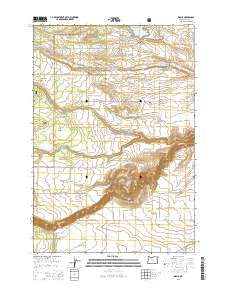
2014 Map of Wamic
USGS Topo · Published 2014About this map
Pine Hollow and Wamic anchor this high-plateau landscape on the eastern edge of the Mount Hood National Forest. The geography is defined by a sophisticated network of irrigation and water management, including the Pine Hollow Reservoir and several man-made conduits such as the Threemile Ditch and Rock Cr Ditch. These systems divert water from the White River and its tributaries across the undulating terrain of Juniper Flat and Smock Prairie. Local history is preserved in the location of the Wamic Cem and the Graveyard Butte Cem near the prominent Graveyard Butte. The map also traces the Wapinitia Canal and Kelly Lateral near the southern settlement of Pine Grove, illustrating the region's enduring reliance on coordinated water distribution for agriculture and settlement life in rural Wasco County.
Find a feature on this map
61 named features on this map. Tap any name to fly to it.
Don’t see what you’re looking for? This feature index may not catch every label — zoom into the map to look around manually.
Map Details
Editions of this 2014 Wamic Map
This is the sole edition of this map. No revisions or reprints were ever made.
Other maps of this area

1930 · Dufur
USGS Topo · 1:125,000

1934 · Dufur
USGS Topo · 1:125,000

1953 · The Dalles
USGS Topo · 1:250,000

1956 · The Dalles
USGS Topo · 1:250,000

1957 · The Dalles
USGS Topo · 1:250,000

1962 · Rock Creek Reservoir
USGS Topo · 1:24,000

1962 · Postage Stamp Butte
USGS Topo · 1:24,000
1962 · Foreman Point
USGS Topo · 1:24,000

1962 · Wamic
USGS Topo · 1:24,000
1962 · Wapinitia
USGS Topo · 1:24,000