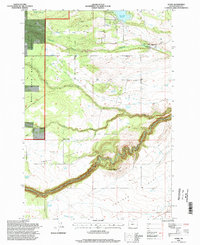
1996 Map of Wamic
USGS Topo · Published 1998About this map
The community of Wamic sits at the edge of a high plateau in Wasco County, where the agricultural landscape meets the eastern boundary of the Mount Hood National Forest. This 1996 update, based on mid-century topography and 1990s imagery, reveals a complex water management system essential to the region, including the Threemile Ditch and the Pine Hollow Reservoir. The southern portion of the map is dominated by the deep, winding canyon of the White River, which carves a sharp path through the high desert terrain.
Find a feature on this map
20 named features on this map. Tap any name to fly to it.
Don’t see what you’re looking for? This feature index may not catch every label — zoom into the map to look around manually.
Map Details
Editions of this 1996 Wamic Map
This is the sole edition of this map. No revisions or reprints were ever made.
Other maps of this area

1930 · Dufur
USGS Topo · 1:125,000

1934 · Dufur
USGS Topo · 1:125,000

1953 · The Dalles
USGS Topo · 1:250,000

1956 · The Dalles
USGS Topo · 1:250,000

1957 · The Dalles
USGS Topo · 1:250,000

1962 · Rock Creek Reservoir
USGS Topo · 1:24,000

1962 · Postage Stamp Butte
USGS Topo · 1:24,000
1962 · Foreman Point
USGS Topo · 1:24,000

1962 · Wamic
USGS Topo · 1:24,000
1962 · Wapinitia
USGS Topo · 1:24,000