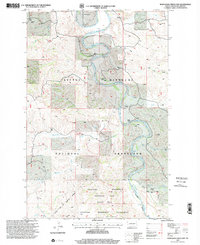
1997 Map of Wannagan Creek East
USGS Topo · Published 2001About this map
The Little Missouri River snakes through the badlands of Billings County in this late-1990s record of a landscape dominated by ranching and federal conservation. The southern portion of the map is defined by the Theodore Roosevelt National Park (South Unit) and the Theodore Roosevelt Wilderness, where the Big Plateau rises above the river valley. The extensive Little Missouri National Grassland surrounds these protected lands, providing a backdrop for numerous private holdings. Family-named outposts like Wolf Ranch, Kruger Ranch, and the Rogne Ranch are scattered across the terrain, connected by the long-distance Maah Daah Hey Trail. Cultural markers of the area's rural history include the Myers Sch and a Scoria Pit, reflecting a community tied to the land's natural resources and the drainage systems of Wannagan Creek and Franks Creek.
Find a feature on this map
30 named features on this map. Tap any name to fly to it.
Don’t see what you’re looking for? This feature index may not catch every label — zoom into the map to look around manually.
Map Details
Editions of this 1997 Wannagan Creek East Map
This is the sole edition of this map. No revisions or reprints were ever made.
Other maps of this area

1953 · Dickinson
USGS Topo · 1:250,000

1953 · Watford City
USGS Topo · 1:250,000

1957 · Dickinson
USGS Topo · 1:250,000

1957 · Watford City
USGS Topo · 1:250,000

1962 · Fryburg NW
USGS Topo · 1:24,000

1963 · Gorham SW
USGS Topo · 1:24,000

1963 · Gorham NW
USGS Topo · 1:24,000

1967 · Watford City
USGS Topo · 1:250,000

1970 · Wannagan Creek East
USGS Topo · 1:24,000

1970 · Roosevelt Creek East
USGS Topo · 1:24,000