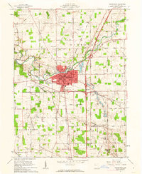
1961 Map of Wapakoneta
USGS Topo · Published 1962About this map
The Auglaize River winds through the heart of this Auglaize County landscape, anchoring the city of Wapakoneta during a period of significant postwar development. The mid-century expansion of the local infrastructure is evident in the path of Interstate 75 cutting north-south across the terrain, contrasting with the established rail corridors of the Baltimore and Ohio and the Erie Railroad.
Find a feature on this map
64 named features on this map. Tap any name to fly to it.
Don’t see what you’re looking for? This feature index may not catch every label — zoom into the map to look around manually.
Map Details
Editions of this 1961 Wapakoneta Map
4 editions found
Other maps of this area

1906 · Lima
USGS Topo · 1:62,500

1909 · Loramie
USGS Topo · 1:62,500

1911 · Loramie
USGS Topo · 1:62,500

1911 · Spencerville
USGS Topo · 1:62,500

1913 · Sidney
USGS Topo · 1:62,500

1944 · Sidney
USGS Topo · 1:62,500

1944 · Loramie
USGS Topo · 1:62,500

1944 · Spencerville
USGS Topo · 1:62,500

1953 · Muncie
USGS Topo · 1:250,000

1956 · Muncie
USGS Topo · 1:250,000