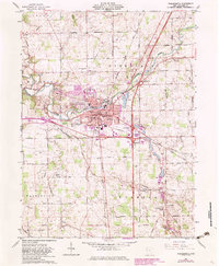
1961 Map of Wapakoneta
USGS Topo · Published 1983About this map
The Auglaize River winds through the heart of this region, shaping the layout of Wapakoneta as it transitioned from a mid-century county seat into a modernizing hub. By the early 1960s, the urban landscape was well-defined by civic staples like the Courthouse, the Blume Sch Library, and the County Fairground. The influence of the Baltimore and Ohio railroad is evident in the industrial corridor near the Canning Factory, while the rural outskirts in Pusheta and Washington townships remain dominated by small family cemeteries and crossroads like Fryburg. A notable historical marker on the landscape is the Old Indian Treaty Boundary Road in the south, preserving a colonial-era survey line amidst a grid of local routes like Burr Oak Road. This 1961 record, later updated with 1980s aerial data, captures the initial expansion of the interstate system across the Quaker Run valley.
Find a feature on this map
72 named features on this map. Tap any name to fly to it.
Don’t see what you’re looking for? This feature index may not catch every label — zoom into the map to look around manually.
Map Details
Editions of this 1961 Wapakoneta Map
4 editions found
Other maps of this area

1906 · Lima
USGS Topo · 1:62,500

1909 · Loramie
USGS Topo · 1:62,500

1911 · Loramie
USGS Topo · 1:62,500

1911 · Spencerville
USGS Topo · 1:62,500

1913 · Sidney
USGS Topo · 1:62,500

1944 · Sidney
USGS Topo · 1:62,500

1944 · Loramie
USGS Topo · 1:62,500

1944 · Spencerville
USGS Topo · 1:62,500

1953 · Muncie
USGS Topo · 1:250,000

1956 · Muncie
USGS Topo · 1:250,000