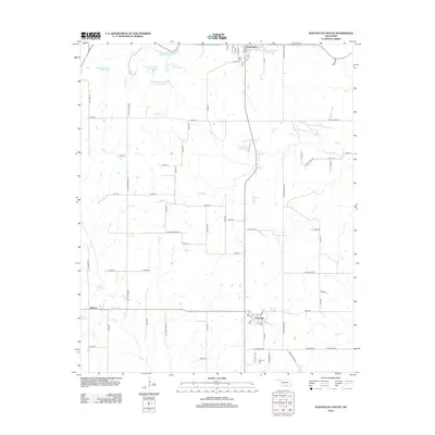
2012 Map of Wapanucka South
USGS Topo · Published 2012About this map
Wapanucka and the surrounding Johnston County landscape are defined by a sophisticated system of water management and rural road networks. Several controlled water bodies, including Delaware Cr Site 3 Reservoir and Delaware Cr Site 5 Reservoir, illustrate the region's focus on flood control and resource preservation. The settlement of Coleman serves as a local hub in the southeastern portion of the map, featuring the Coleman Cem and a grid of residential streets like Main St and Grand St. To the west, the community of Fillmore sits near Smith Lake, connected by a web of section-line roads such as S Luffy Chapel Rd and S Fillmore Rd. The natural drainage of the land is visible through the winding paths of Sandy Cr and Sulphur Br, which contrast with the rigid geometric layout of the surrounding agricultural parcels.
Find a feature on this map
81 named features on this map. Tap any name to fly to it.
Don’t see what you’re looking for? This feature index may not catch every label — zoom into the map to look around manually.
Map Details
Editions of this 2012 Wapanucka South Map
This is the sole edition of this map. No revisions or reprints were ever made.
Other maps of this area

1899 · Atoka
USGS Topo · 1:125,000

1900 · Atoka
USGS Topo · 1:125,000

1901 · Tishomingo
USGS Topo · 1:125,000

1957 · Ardmore
USGS Topo · 1:250,000

1963 · Ardmore
USGS Topo · 1:250,000

1967 · Connerville SE
USGS Topo · 1:24,000
1967 · Connerville NE
USGS Topo · 1:24,000
1967 · Milburn
USGS Topo · 1:24,000
1968 · Wapanucka South
USGS Topo · 1:24,000

1968 · Caddo NW
USGS Topo · 1:24,000