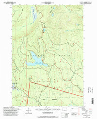
1996 Map of Wapinitia Pass
USGS Topo · Published 1998About this map
Warm Springs Indian Reservation lands meet the Mount Hood National Forest in this mid-1990s survey of the High Cascades. The map is defined by its diverse water features and high-altitude terrain, centered on the expansive Clear Lake and the smaller, distinct Little Crater Lake. The latter is part of the Little Crater Lake Geological Area, known for its artesian spring and crystal-clear waters. Historical transit is etched across the landscape, notably the Barlow Road and the Mc Quinn Line 1887, reflecting early migration and boundary surveys in Oregon. The modern Pacific Crest trail winds through the western half of the quadrangle, crossing near Salmon River Meadows and the headwaters of the Salmon River. These features illustrate the area's transition from a pioneer-era transit corridor to a late-20th-century conservation and recreation landscape.
Find a feature on this map
35 named features on this map. Tap any name to fly to it.
Don’t see what you’re looking for? This feature index may not catch every label — zoom into the map to look around manually.
Map Details
Editions of this 1996 Wapinitia Pass Map
This is the sole edition of this map. No revisions or reprints were ever made.
Other maps of this area

1924 · Mount Hood
USGS Topo · 1:125,000

1927 · Mount Hood
USGS Topo · 1:125,000

1953 · The Dalles
USGS Topo · 1:250,000

1956 · The Dalles
USGS Topo · 1:250,000

1956 · High Rock
USGS Topo · 1:62,500

1956 · Mt. Wilson
USGS Topo · 1:62,500

1957 · The Dalles
USGS Topo · 1:250,000
1962 · Badger Lake
USGS Topo · 1:24,000
1962 · Government Camp
USGS Topo · 1:24,000
1962 · Timberline Lodge
USGS Topo · 1:24,000