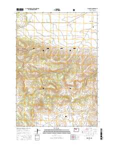
2017 Map of Wapinitia
USGS Topo · Published 2017About this map
Juniper Flat dominates the northern landscape of this region, where the small agricultural settlements of Pine Grove and Wapinitia sit along the route of the old Barlow Road. The topography shifts dramatically as the flat plateau gives way to the complex drainages of Wapinitia Cr and Rice Cr before descending into the steep ridges of the Laughlin Hills. This transition from open range to the timbered slopes of the Mount Hood National Forest reflects the varied land use in this part of Wasco County.
Find a feature on this map
45 named features on this map. Tap any name to fly to it.
Don’t see what you’re looking for? This feature index may not catch every label — zoom into the map to look around manually.
Map Details
Editions of this 2017 Wapinitia Map
This is the sole edition of this map. No revisions or reprints were ever made.
Other maps of this area

1928 · Madras
USGS Topo · 1:125,000

1930 · Dufur
USGS Topo · 1:125,000

1931 · Madras
USGS Topo · 1:125,000

1934 · Dufur
USGS Topo · 1:125,000

1953 · The Dalles
USGS Topo · 1:250,000

1955 · Bend
USGS Topo · 1:250,000

1956 · The Dalles
USGS Topo · 1:250,000

1957 · Bend
USGS Topo · 1:250,000

1957 · The Dalles
USGS Topo · 1:250,000

1958 · Bend
USGS Topo · 1:250,000