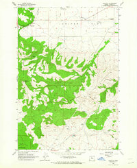
1962 Map of Wapinitia
USGS Topo · Published 1964About this map
Juniper Flat dominates the northern landscape of this Wasco County region, where the small community of Wapinitia serves as a local hub. The area is defined by a transition from the level plateau of the flat to the deeply etched terrain of the Laughlin Hills and Paquet Gulch to the south. Much of the southern portion is part of the Warm Springs Indian Reservation, where significant historical survey markers like the Campbell Line-1873 and the Mc Quinn Line-1887 delineate boundary shifts from the late 19th century.
Find a feature on this map
29 named features on this map. Tap any name to fly to it.
Don’t see what you’re looking for? This feature index may not catch every label — zoom into the map to look around manually.
Map Details
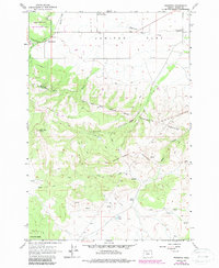
Editions of this 1962 Wapinitia Map
2 editions found
Other maps of this area

1928 · Madras
USGS Topo · 1:125,000

1930 · Dufur
USGS Topo · 1:125,000

1931 · Madras
USGS Topo · 1:125,000

1934 · Dufur
USGS Topo · 1:125,000

1953 · The Dalles
USGS Topo · 1:250,000

1955 · Bend
USGS Topo · 1:250,000

1956 · The Dalles
USGS Topo · 1:250,000

1957 · Bend
USGS Topo · 1:250,000

1957 · The Dalles
USGS Topo · 1:250,000

1958 · Bend
USGS Topo · 1:250,000