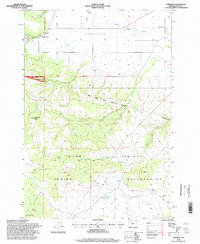
1996 Map of Wapinitia
USGS Topo · Published 1998About this map
Juniper Flat dominates the northern landscape of this Wasco County region, where the small settlements of Pine Grove and Wapinitia sit atop the high plateau. The map details a significant cultural and administrative boundary, tracing the Warm Springs Indian Reservation Boundary as it cuts across the Laughlin Hills and Paquet Gulch. This boundary includes a reference to the historic McQuinn Line 1884, a crucial marker in Oregon land survey history. To the west, the evergreen expanse of the Mount Hood National Forest begins, while the southern portion of the map is defined by the canyon-carved terrain of the Warm Springs Indian Reservation. Local landmarks such as the Oak Grove Sch, the Rainbow Quarry, and several high points like Simnasho Butte provide specific points of interest for those studying the rural infrastructure and geography of the area in the late twentieth century.
Find a feature on this map
25 named features on this map. Tap any name to fly to it.
Don’t see what you’re looking for? This feature index may not catch every label — zoom into the map to look around manually.
Map Details
Editions of this 1996 Wapinitia Map
This is the sole edition of this map. No revisions or reprints were ever made.
Other maps of this area

1928 · Madras
USGS Topo · 1:125,000

1930 · Dufur
USGS Topo · 1:125,000

1931 · Madras
USGS Topo · 1:125,000

1934 · Dufur
USGS Topo · 1:125,000

1953 · The Dalles
USGS Topo · 1:250,000

1955 · Bend
USGS Topo · 1:250,000

1956 · The Dalles
USGS Topo · 1:250,000

1957 · Bend
USGS Topo · 1:250,000

1957 · The Dalles
USGS Topo · 1:250,000

1958 · Bend
USGS Topo · 1:250,000