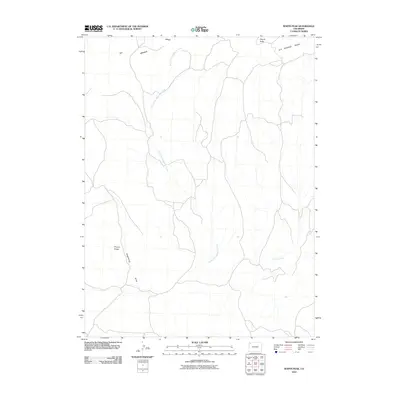
2010 Map of Wapiti Peak
USGS Topo · Published 2010About this map
Wapiti Peak serves as a central landmark in this high-elevation corner of Moffat County, where the terrain is defined by prominent ridges and seasonal drainages. The landscape is dominated by the massive Elk Springs Ridge to the north and Pinyon Ridge to the southwest, reflecting the remote, high-desert character of the Western Slope. These uplands are dissected by a network of ephemeral watercourses including North Fork Sagebrush Creek and Crooked Wash, which funnel runoff through the arid valley floors.
Find a feature on this map
7 named features on this map. Tap any name to fly to it.
Don’t see what you’re looking for? This feature index may not catch every label — zoom into the map to look around manually.
Map Details
Editions of this 2010 Wapiti Peak Map
This is the sole edition of this map. No revisions or reprints were ever made.
Other maps of this area

1907 · White River
USGS Topo · 1:125,000

1910 · White River
USGS Topo · 1:125,000

1954 · Vernal
USGS Topo · 1:250,000

1958 · Vernal
USGS Topo · 1:250,000

1958 · Citadel Plateau
USGS Topo · 1:62,500

1960 · Vernal
USGS Topo · 1:250,000

1960 · Elk Springs
USGS Topo · 1:62,500
1966 · Smizer Gulch
USGS Topo · 1:24,000
1966 · Rough Gulch
USGS Topo · 1:24,000
1966 · Indian Valley
USGS Topo · 1:24,000