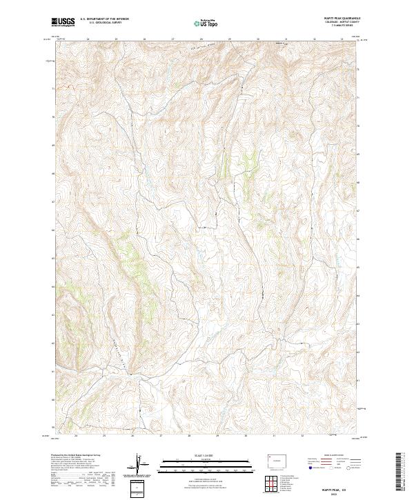
2022 Map of Wapiti Peak
USGS Topo · Published 2022About this map
Wapiti Peak serves as a prominent landmark in this portion of Moffat County, overlooking a landscape defined by an intricate network of seasonal drainages and dry washes. The terrain transitions from the high elevations of Elk Springs Ridge in the north toward the lower reaches of Sagebrush Draw and Crooked Wash to the south. The drainage pattern, including N Fork Sagebrush Cr and Coal Cr, illustrates the erosional forces that have shaped this high-desert environment. This modern survey, produced using data from the Bureau of Land Management and the National Hydrography Dataset, offers a detailed look at the Public Land Survey System (PLSS) grid, documenting township and range boundaries like t4n r97w that still govern land management in this cattle-ranching and energy-producing region of Northwest Colorado.
Find a feature on this map
12 named features on this map. Tap any name to fly to it.
Don’t see what you’re looking for? This feature index may not catch every label — zoom into the map to look around manually.
Map Details
Editions of this 2022 Wapiti Peak Map
This is the sole edition of this map. No revisions or reprints were ever made.
Other maps of this area

1907 · White River
USGS Topo · 1:125,000

1910 · White River
USGS Topo · 1:125,000

1954 · Vernal
USGS Topo · 1:250,000

1958 · Vernal
USGS Topo · 1:250,000

1958 · Citadel Plateau
USGS Topo · 1:62,500

1960 · Vernal
USGS Topo · 1:250,000

1960 · Elk Springs
USGS Topo · 1:62,500
1966 · Smizer Gulch
USGS Topo · 1:24,000
1966 · Rough Gulch
USGS Topo · 1:24,000
1966 · Indian Valley
USGS Topo · 1:24,000