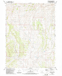
1986 Map of Wapiti Peak
USGS Topo · Published 1986About this map
Wapiti Peak serves as the high point in this corner of Moffat County, overlooking the dissected terrain of Elk Springs Ridge. The landscape is defined by its drainage patterns, notably North Fork Sagebrush Creek and the long course of Sagebrush Draw, which carve through the arid high country. The U.S. Geological Survey mapping, based on 1981 aerial photography, documents a region primarily utilized for resource exploration and livestock grazing. Evidence of industrial activity is sparse but specific, marked by a Drill Hole located in the western portion of the sheet. Seasonal water sources are critical here, with various unnamed springs and ephemeral channels like Crooked Wash and Spring Wash tracing the natural hydrology of the basin.
Find a feature on this map
8 named features on this map. Tap any name to fly to it.
Don’t see what you’re looking for? This feature index may not catch every label — zoom into the map to look around manually.
Map Details
Editions of this 1986 Wapiti Peak Map
This is the sole edition of this map. No revisions or reprints were ever made.
Other maps of this area

1907 · White River
USGS Topo · 1:125,000

1910 · White River
USGS Topo · 1:125,000

1954 · Vernal
USGS Topo · 1:250,000

1958 · Vernal
USGS Topo · 1:250,000

1958 · Citadel Plateau
USGS Topo · 1:62,500

1960 · Vernal
USGS Topo · 1:250,000

1960 · Elk Springs
USGS Topo · 1:62,500
1966 · Smizer Gulch
USGS Topo · 1:24,000
1966 · Rough Gulch
USGS Topo · 1:24,000
1966 · Indian Valley
USGS Topo · 1:24,000