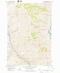
1963 Map of Wapshilla Creek
USGS Topo · Published 1979About this map
Craig Mountain and Wapshilla Ridge dominate this rugged canyon landscape where the Snake River carves the border between Idaho and Oregon. Surveyed in the early 1960s, the terrain shows the dramatic confluence of the Snake and the Salmon River, a region defined by steep elevational shifts and remote water features. The river corridors are marked by navigational hazards and seasonal landmarks like Wapshilla Rapids, Frenchy Rapids, and Geneva Bar. Within the Wallowa National Forest, the map records numerous water sources essential for backcountry travel and livestock, including Hot Spring, Coyote Spr, and several drainages such as Cottonwood Creek and Birch Creek. A network of unnamed trails and jeep trails provides the only evidence of human transit through these formidable ridges and draws.
Find a feature on this map
42 named features on this map. Tap any name to fly to it.
Don’t see what you’re looking for? This feature index may not catch every label — zoom into the map to look around manually.
Map Details
Editions of this 1963 Wapshilla Creek Map
2 editions found
Other maps of this area

1946 · Limekiln Rapids
USGS Topo · 1:62,500

1955 · Pullman
USGS Topo · 1:250,000

1955 · Grangeville
USGS Topo · 1:250,000

1958 · Pullman
USGS Topo · 1:250,000

1959 · Grangeville
USGS Topo · 1:250,000

1963 · Cactus Mtn
USGS Topo · 1:24,000

1963 · Deadhorse Ridge
USGS Topo · 1:24,000

1963 · Jim Creek Butte
USGS Topo · 1:24,000

1963 · Rattlesnake Ridge
USGS Topo · 1:24,000

1963 · Wapshilla Creek
USGS Topo · 1:24,000