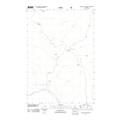
2011 Map of War Eagle Mountain
USGS Topo · Published 2011About this map
War Eagle Mountain and its surrounding peaks define this high-altitude landscape in the Payette National Forest. Historically centered on mineral extraction, the area is home to the Golden Rule Placer Mine and Humboldt Mine, remnants of the region's mining legacy. Drainage patterns are complex, with the Secesh River winding through the southern portion while numerous creeks like California Creek, Piah Creek, and Warm Spring Creek carve through the steep terrain. The presence of the War Eagle Mountain Lookout suggests the strategic importance of this summit for forest management and fire observation. High mountain meadows, including Kelly Meadows and Floyd Meadows, offer a glimpse into the seasonal vegetation patterns of central Idaho. Infrastructure is limited to forest roads like Warren Wagon RD, highlighting the remote and specialized nature of this backcountry locale.
Find a feature on this map
28 named features on this map. Tap any name to fly to it.
Don’t see what you’re looking for? This feature index may not catch every label — zoom into the map to look around manually.
Map Details
Editions of this 2011 War Eagle Mountain Map
This is the sole edition of this map. No revisions or reprints were ever made.
Other maps of this area

1956 · Burgdorf
USGS Topo · 1:62,500

1956 · Warren
USGS Topo · 1:62,500

1956 · Elk City
USGS Topo · 1:250,000

1960 · Elk City
USGS Topo · 1:250,000

1969 · Loon Lake
USGS Topo · 1:24,000

1969 · Pony Meadows
USGS Topo · 1:24,000
1969 · Victor Peak
USGS Topo · 1:24,000

1981 · Warren
USGS Topo · 1:100,000
1989 · Johnson Butte
USGS Topo · 1:24,000
1989 · Warren
USGS Topo · 1:24,000