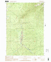
1989 Map of Warren
USGS Topo · Published 1990About this map
Warren serves as the central hub of activity in this high-altitude region of the Payette National Forest, situated along the course of Warren Creek. The landscape is heavily defined by its mining legacy, with extensive tailings deposits following the creek beds near the settlement and northward toward Republican Flats. Evidence of land management and transportation infrastructure is clear, from the Mitchell Guard Station to the Warren Airport and the winding route of the Warren Wagon Road.
Find a feature on this map
35 named features on this map. Tap any name to fly to it.
Don’t see what you’re looking for? This feature index may not catch every label — zoom into the map to look around manually.
Map Details
Editions of this 1989 Warren Map
2 editions found
Other maps of this area

1956 · Burgdorf
USGS Topo · 1:62,500

1956 · Warren
USGS Topo · 1:62,500

1956 · Elk City
USGS Topo · 1:250,000

1960 · Elk City
USGS Topo · 1:250,000

1969 · Loon Lake
USGS Topo · 1:24,000

1969 · Pony Meadows
USGS Topo · 1:24,000

1969 · Pilot Peak
USGS Topo · 1:24,000

1981 · Warren
USGS Topo · 1:100,000
1989 · Mackay Bar
USGS Topo · 1:24,000
1989 · Johnson Butte
USGS Topo · 1:24,000