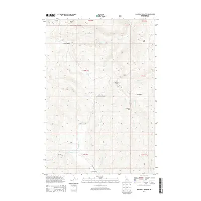
2013 Map of War Eagle Mountain
USGS Topo · Published 2013About this map
War Eagle Mountain Lookout stands as a sentinel over the high-altitude terrain of the Payette National Forest in this 2013 survey. The landscape is defined by the headwaters of numerous drainages, including California Cr and Warm Spring Cr, which carve through a region dominated by prominent peaks like Marshall Mtn and War Eagle Mtn. In the southern portion of the quadrangle, the Secesh River meanders through the relatively level ground of Secesh Meadows, a notable contrast to the steep surrounding ridges.
Find a feature on this map
34 named features on this map. Tap any name to fly to it.
Don’t see what you’re looking for? This feature index may not catch every label — zoom into the map to look around manually.
Map Details
Editions of this 2013 War Eagle Mountain Map
This is the sole edition of this map. No revisions or reprints were ever made.
Other maps of this area

1956 · Burgdorf
USGS Topo · 1:62,500

1956 · Warren
USGS Topo · 1:62,500

1956 · Elk City
USGS Topo · 1:250,000

1960 · Elk City
USGS Topo · 1:250,000

1969 · Loon Lake
USGS Topo · 1:24,000

1969 · Pony Meadows
USGS Topo · 1:24,000
1969 · Victor Peak
USGS Topo · 1:24,000

1981 · Warren
USGS Topo · 1:100,000
1989 · Johnson Butte
USGS Topo · 1:24,000
1989 · Warren
USGS Topo · 1:24,000