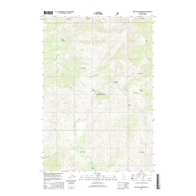
2017 Map of War Eagle Mountain
USGS Topo · Published 2017About this map
War Eagle Mountain and Marshall Mtn anchor this high-elevation landscape within the Payette National Forest in central Idaho. The terrain is defined by a network of drainage basins, including the southern flow of the Secesh River and the winding Jeanette Creek to the northwest. This 2017 survey details the remote backcountry infrastructure of Idaho County, showing the path of Warren Wagon Rd and the Natl Forest Develop Road 325 Rd as they navigate the ridges and basins. Named clearings and geological landmarks such as Kelly Meadows, Floyd Meadows, and the distinct Chimney Rock highlight points of interest for those navigating the wilderness. The map also records smaller alpine features like California Lake and the high-altitude Rye Patch, providing a precise record of the regional topography and the intricate hydrography of creeks such as Union Cr and California Cr.
Find a feature on this map
36 named features on this map. Tap any name to fly to it.
Don’t see what you’re looking for? This feature index may not catch every label — zoom into the map to look around manually.
Map Details
Editions of this 2017 War Eagle Mountain Map
This is the sole edition of this map. No revisions or reprints were ever made.
Other maps of this area

1956 · Burgdorf
USGS Topo · 1:62,500

1956 · Warren
USGS Topo · 1:62,500

1956 · Elk City
USGS Topo · 1:250,000

1960 · Elk City
USGS Topo · 1:250,000

1969 · Loon Lake
USGS Topo · 1:24,000

1969 · Pony Meadows
USGS Topo · 1:24,000
1969 · Victor Peak
USGS Topo · 1:24,000

1981 · Warren
USGS Topo · 1:100,000
1989 · Johnson Butte
USGS Topo · 1:24,000
1989 · Warren
USGS Topo · 1:24,000