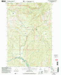
2004 Map of War Eagle Mountain
USGS Topo · Published 2007About this map
War Eagle Mountain dominates the center of this 2004 revision of the Payette National Forest landscape, surrounded by high-elevation peaks and meadows. The area reveals a significant history of resource extraction, with the Humboldt Mine and numerous prospects scattered near California Creek and the Secesh River. These labels, alongside identified Tailings and Open Pit Mines, trace a legacy of hard-rock mining and prospecting that defined this part of the Idaho mountains for generations.
Find a feature on this map
37 named features on this map. Tap any name to fly to it.
Don’t see what you’re looking for? This feature index may not catch every label — zoom into the map to look around manually.
Map Details
Editions of this 2004 War Eagle Mountain Map
This is the sole edition of this map. No revisions or reprints were ever made.
Other maps of this area

1956 · Burgdorf
USGS Topo · 1:62,500

1956 · Warren
USGS Topo · 1:62,500

1956 · Elk City
USGS Topo · 1:250,000

1960 · Elk City
USGS Topo · 1:250,000

1969 · Loon Lake
USGS Topo · 1:24,000

1969 · Pony Meadows
USGS Topo · 1:24,000
1969 · Victor Peak
USGS Topo · 1:24,000

1981 · Warren
USGS Topo · 1:100,000
1989 · Johnson Butte
USGS Topo · 1:24,000
1989 · Warren
USGS Topo · 1:24,000