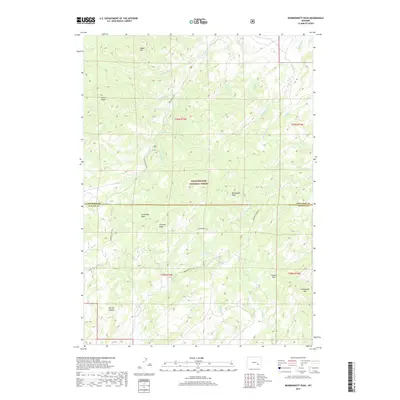
2017 Map of Warbonnett Peak
USGS Topo · Published 2017About this map
Medicine Bow National Forest dominates this high-altitude landscape along the border of Converse and Albany counties. The terrain is defined by prominent summits and ridges, including the central Warbonnet Peak and the nearby Chimney Ridge, which overlook deep drainages like Parsons Canyon. This 2017 survey reveals a remote backcountry structured by limited access routes such as Cold Springs Rd and Warbonnet Peak Rd. The complex hydrology is evident in the numerous tributaries of La Prele Cr and Beaver Cr, which carve through the basins and passes of the Laramie Mountains. Features like Fackler Pass and Coverdale Basin suggest the traditional transit corridors used by ranchers and outdoorsmen in this sparsely settled region of Wyoming.
Find a feature on this map
38 named features on this map. Tap any name to fly to it.
Don’t see what you’re looking for? This feature index may not catch every label — zoom into the map to look around manually.
Map Details
Editions of this 2017 Warbonnett Peak Map
This is the sole edition of this map. No revisions or reprints were ever made.
Other maps of this area

1954 · Torrington
USGS Topo · 1:250,000

1958 · Torrington
USGS Topo · 1:250,000

1964 · Toltec
USGS Topo · 1:24,000

1964 · Buck Peak
USGS Topo · 1:24,000

1964 · School Section Mountain
USGS Topo · 1:24,000

1964 · Buffalo Peak
USGS Topo · 1:24,000
1964 · Blue Nose Creek
USGS Topo · 1:24,000
1964 · Rock Creek
USGS Topo · 1:24,000
1964 · Pass Creek
USGS Topo · 1:24,000

1964 · Marshall
USGS Topo · 1:24,000