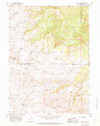
1964 Map of Rock Creek
USGS Topo · Published 1968About this map
Medicine Bow National Forest dominates the upper half of this high-plains landscape, where the headwaters of numerous creeks carve through the terrain. The map records a sparsely settled ranching and wilderness area at the boundary of Converse and Albany counties, defined by natural landmarks like Breakneck Hill and Peach Orchard. The hydrological network is the primary feature of this survey, anchored by the North Fork Little Medicine Bow River and the South Fork Little Medicine Bow River, which converge amidst a web of drainage like Cruikshank Creek and Bell Creek.
Find a feature on this map
25 named features on this map. Tap any name to fly to it.
Don’t see what you’re looking for? This feature index may not catch every label — zoom into the map to look around manually.
Map Details
Editions of this 1964 Rock Creek Map
2 editions found

Other maps of this area

1954 · Torrington
USGS Topo · 1:250,000

1955 · Casper
USGS Topo · 1:250,000

1958 · Casper
USGS Topo · 1:250,000

1958 · Torrington
USGS Topo · 1:250,000

1959 · Squaw Spring
USGS Topo · 1:24,000

1959 · Chalk Hills
USGS Topo · 1:24,000

1960 · Reno Hill
USGS Topo · 1:24,000

1962 · Casper
USGS Topo · 1:250,000

1964 · Buck Peak
USGS Topo · 1:24,000

1964 · Buffalo Peak
USGS Topo · 1:24,000