
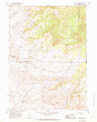
1964 Map of Rock Creek
USGS Topo · Published 1985About this map
Medicine Bow National Forest dominates the high-altitude landscape of this 1960s survey, updated in the mid-1980s to show the shifting terrain of the Wyoming wilderness. The topography is defined by the complex drainage systems of the Little Medicine Bow River, including the North Prong Little Medicine Bow River and South Prong Little Medicine Bow River. Human presence is sparse, marked primarily by remote sites such as Russells Camp and the evocative The Peach Orchard located along Sleepy Jack Creek. The map documents the rugged interface of Converse Co and Albany Co near Little Medicine Falls, where steep elevations like Breakneck Hill rise above the network of springs and creeks. A single 4wd trail provides the only indicated vehicular access through this section of the Laramie Mountains foothills.
Find a feature on this map
23 named features on this map. Tap any name to fly to it.
Don’t see what you’re looking for? This feature index may not catch every label — zoom into the map to look around manually.
Map Details
Editions of this 1964 Rock Creek Map
2 editions found
Other maps of this area

1954 · Torrington
USGS Topo · 1:250,000

1955 · Casper
USGS Topo · 1:250,000

1958 · Casper
USGS Topo · 1:250,000

1958 · Torrington
USGS Topo · 1:250,000

1959 · Squaw Spring
USGS Topo · 1:24,000

1959 · Chalk Hills
USGS Topo · 1:24,000

1960 · Reno Hill
USGS Topo · 1:24,000

1962 · Casper
USGS Topo · 1:250,000

1964 · Buck Peak
USGS Topo · 1:24,000

1964 · Buffalo Peak
USGS Topo · 1:24,000