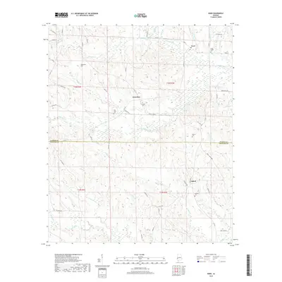
2018 Map of Ward
USGS Topo · Published 2018About this map
The border of Sumter Co and Choctaw Co divides this rural West Alabama landscape, where small hamlets and family burial grounds are dispersed among a complex network of creeks. The settlement of Ward anchors the northern portion of the map, situated near Cokes Chapel Cem, while the community of Halsell sits further south along Jack Br. The terrain is defined by the winding course of Kinterbish Cr and its many tributaries, including Little Kinterbish Cr and Thornton Cr, which have shaped the local topography near Thornton Hill. Genealogists will find several notable local landmarks, including Beulah Cem, Pine Grove Cem, Shearon Cem, and Fairfield Cem. The road network, featuring routes like Woodward St and Charles Spur Rd, reflects the area's agricultural and timber-focused land use patterns typical of the Black Belt region.
Find a feature on this map
59 named features on this map. Tap any name to fly to it.
Don’t see what you’re looking for? This feature index may not catch every label — zoom into the map to look around manually.
Map Details
Editions of this 2018 Ward Map
This is the sole edition of this map. No revisions or reprints were ever made.
Other maps of this area

1953 · Meridian
USGS Topo · 1:250,000

1957 · Meridian
USGS Topo · 1:250,000

1965 · Meridian
USGS Topo · 1:250,000

1971 · Gaston
USGS Topo · 1:24,000

1971 · Bellamy
USGS Topo · 1:24,000

1974 · Yantley
USGS Topo · 1:24,000

1974 · Ward
USGS Topo · 1:24,000

1974 · Lisman
USGS Topo · 1:24,000
1974 · York
USGS Topo · 1:24,000
1974 · Kewanee
USGS Topo · 1:24,000