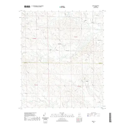
2020 Map of Ward
USGS Topo · Published 2020About this map
The boundary between Sumter and Choctaw Counties bisects this West Alabama landscape, a region defined by its dense network of creeks and small settlements. The community of Ward serves as a northern focal point, while the smaller hamlets of Kinterbish and Halsell anchor the central and southern sections of the map. This area is heavily forested and crisscrossed by waterways such as Thornton Creek and the meandering Kinterbish Creek. Several family and community burial grounds, including Fairfield Cemetery, Beulah Cemetery, and Pine Grove Cemetery, are scattered throughout the quadrangle, indicating a long-established rural population. The terrain rises to its most prominent point at Thornton Hill in the northwest, providing a clear picture of the local topography and the dispersed road network connecting these rural outposts.
Find a feature on this map
61 named features on this map. Tap any name to fly to it.
Don’t see what you’re looking for? This feature index may not catch every label — zoom into the map to look around manually.
Map Details
Editions of this 2020 Ward Map
This is the sole edition of this map. No revisions or reprints were ever made.
Other maps of this area

1953 · Meridian
USGS Topo · 1:250,000

1957 · Meridian
USGS Topo · 1:250,000

1965 · Meridian
USGS Topo · 1:250,000

1971 · Gaston
USGS Topo · 1:24,000

1971 · Bellamy
USGS Topo · 1:24,000

1974 · Yantley
USGS Topo · 1:24,000

1974 · Ward
USGS Topo · 1:24,000

1974 · Lisman
USGS Topo · 1:24,000
1974 · York
USGS Topo · 1:24,000
1974 · Kewanee
USGS Topo · 1:24,000