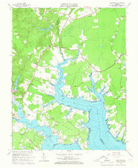
1965 Map of Ware Neck
USGS Topo · Published 1966About this map
The coastal peninsula of Ware Neck and its neighboring fingers of land are defined by the intricate tides of the Ware River and North River. During this mid-century period, the landscape is a mosaic of tidal flats and established waterfront estates like Glen Roy Estates. The maritime character of the region is evident in landmarks such as Auburn Wharf and several navigational aids, including Cradle Pt Light and Lone Point Light. Small crossroads communities like James Store and Nuttall anchor the interior, often centered around local congregations such as Spring Hill Ch or Locust Grove Ch. The presence of Fort Nonsense near the center of the sheet provides a historical reference point amidst the network of creeks and necks that dominate the Gloucester and Mathews County shoreline.
Find a feature on this map
61 named features on this map. Tap any name to fly to it.
Don’t see what you’re looking for? This feature index may not catch every label — zoom into the map to look around manually.
Map Details
Editions of this 1965 Ware Neck Map
4 editions found
Other maps of this area

1906 · Williamsburg
USGS Topo · 1:62,500

1916 · Kilmarnock
USGS Topo · 1:48,000

1916 · Mathews
USGS Topo · 1:62,500

1917 · Urbanna
USGS Topo · 1:62,500

1917 · Kilmarnock
USGS Topo · 1:62,500

1917 · Mathews
USGS Topo · 1:62,500

1942 · Kilmarnock
USGS Topo · 1:62,500

1943 · Richmond
USGS Topo · 1:250,000

1948 · Ware Neck
USGS Topo · 1:24,000

1948 · Achilles
USGS Topo · 1:24,000