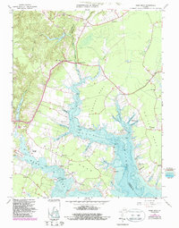
1965 Map of Ware Neck
USGS Topo · Published 1987About this map
Fort Nonsense stands as a prominent landmark in the upper portion of this survey, overlooking the complex wetlands and tidal inlets that define Gloucester County. The landscape is characterized by its numerous peninsulas, or necks, including White Neck and Chapel Neck, which extend into the North Ware River. This coastal geometry dictated the settlement patterns of the mid-20th century, where life was anchored by water access at places like Auburn Wharf and Baileys Wharf.
Find a feature on this map
64 named features on this map. Tap any name to fly to it.
Don’t see what you’re looking for? This feature index may not catch every label — zoom into the map to look around manually.
Map Details
Editions of this 1965 Ware Neck Map
4 editions found
Other maps of this area

1906 · Williamsburg
USGS Topo · 1:62,500

1916 · Kilmarnock
USGS Topo · 1:48,000

1916 · Mathews
USGS Topo · 1:62,500

1917 · Urbanna
USGS Topo · 1:62,500

1917 · Kilmarnock
USGS Topo · 1:62,500

1917 · Mathews
USGS Topo · 1:62,500

1942 · Kilmarnock
USGS Topo · 1:62,500

1943 · Richmond
USGS Topo · 1:250,000

1948 · Ware Neck
USGS Topo · 1:24,000

1948 · Achilles
USGS Topo · 1:24,000