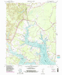
1965 Map of Ware Neck
USGS Topo · Published 1987About this map
Fort Nonsense stands as a prominent landmark on this mid-century survey of the Tidewater region, where the intricate geography of the Ware River meets the North River. The landscape is defined by long, slender peninsulas including Chapel Neck, White Neck, and Ware Neck, each reaching into the Chesapeake's tributaries. Small agricultural and maritime hubs like James Store, Schley, and Zanoni are connected by a network of state routes, while the shoreline is dotted with historical maritime infrastructure such as Auburn Wharf and the Baileys Wharf Beacon.
Find a feature on this map
92 named features on this map. Tap any name to fly to it.
Don’t see what you’re looking for? This feature index may not catch every label — zoom into the map to look around manually.
Map Details
Editions of this 1965 Ware Neck Map
4 editions found
Other maps of this area

1906 · Williamsburg
USGS Topo · 1:62,500

1916 · Kilmarnock
USGS Topo · 1:48,000

1916 · Mathews
USGS Topo · 1:62,500

1917 · Urbanna
USGS Topo · 1:62,500

1917 · Kilmarnock
USGS Topo · 1:62,500

1917 · Mathews
USGS Topo · 1:62,500

1942 · Kilmarnock
USGS Topo · 1:62,500

1943 · Richmond
USGS Topo · 1:250,000

1948 · Ware Neck
USGS Topo · 1:24,000

1948 · Achilles
USGS Topo · 1:24,000