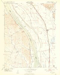
1948 Map of Ware
USGS Topo · Published 1948About this map
The Mississippi River serves as the central artery for this riverfront landscape, dividing Union County, Illinois, from Cape Girardeau County, Missouri. In this post-war era, the floodplain is a complex network of levees, drainage ditches like the Running Lake Ditch, and prominent towheads such as Vancill Towhead and Swiftsure Towhead. This map captures a moment when rural river life was still anchored by numerous small schoolhouses and landings. Inland from the banks, the settlement at Ware acts as a junction for the Illinois Central and Missouri Pacific railroads, which parallel the river's eastern shore. To the west, the Missouri side reveals more varied topography, with the community of Egypt Mills and the winding Flora Creek tucked into the bluffs, while the St Louis San Francisco rail line traces the Missouri riverbank through Moccasin Springs.
Find a feature on this map
36 named features on this map. Tap any name to fly to it.
Don’t see what you’re looking for? This feature index may not catch every label — zoom into the map to look around manually.
Map Details
Editions of this 1948 Ware Map
2 editions found
Other maps of this area

1918 · Altenburg
USGS Topo · 1:62,500

1920 · Jonesboro
USGS Topo · 1:62,500

1922 · Cape Girardeau
USGS Topo · 1:62,500

1923 · Jonesboro
USGS Topo · 1:62,500

1924 · Cape Girardeau
USGS Topo · 1:62,500

1924 · Alto Pass
USGS Topo · 1:62,500

1925 · Altenburg
USGS Topo · 1:62,500

1947 · Jonesboro
USGS Topo · 1:62,500

1947 · Alto Pass
USGS Topo · 1:62,500

1947 · Mc Clure
USGS Topo · 1:24,000