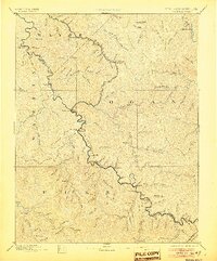
1891 Map of Warfield
USGS Topo · Published 1905About this map
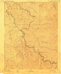
The West Virginia Kentucky Boundary Line follows the winding course of the Tug Fork, anchoring a landscape defined by the arrival of the Norfolk and Western R.R. Ken Ova Division. This 1880s survey reflects the early industrial character of Martin, Logan, Wayne, and Pike counties. Settlements like Williamson and Matewan appear alongside numerous family-named landmarks and mountain hollows, including Hatfield, Delorme, and White Post. In the northeastern corner, the Guyandotte River cuts through the terrain near Chapmansville, while the interior is a dense network of drainages such as Blackberry Fork and Rockhouse Fork. The rail line, following the river valley through Naugatuck and Dingess, signifies the transformative era of coal and timber transport that shaped these border communities during the late nineteenth century.
Find a feature on this map
109 named features on this map. Tap any name to fly to it.
Don’t see what you’re looking for? This feature index may not catch every label — zoom into the map to look around manually.
Map Details
Editions of this 1891 Warfield Map
7 editions found
Other maps of this area

1886 · Prestonsburg
USGS Topo · 1:125,000

1886 · Grundy
USGS Topo · 1:125,000

1887 · Warfield
USGS Topo · 1:125,000

1890 · Whitesburg
USGS Topo · 1:125,000

1890 · Grundy
USGS Topo · 1:125,000

1891 · Tazewell
USGS Topo · 1:125,000

1891 · Oceana
USGS Topo · 1:125,000

1891 · Warfield
USGS Topo · 1:125,000

1892 · Grundy
USGS Topo · 1:125,000

1892 · Whitesburg
USGS Topo · 1:125,000