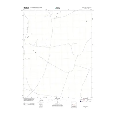
2010 Map of Warm Point
USGS Topo · Published 2010About this map
The Confusion Range dominates the western portion of this high desert terrain in Millard County, Utah. Recorded in 2010, the landscape is defined by its dramatic topographic relief, where Smooth Canyon cuts through the ridges and Blind Valley nestles between the peaks. The namesake Warm Point stands as a significant landmark above the surrounding flats, positioned between the range and the eastern Barn Hills. Settlement is virtually non-existent here, with the human footprint limited to essential desert transit routes such as Crystal Peak Rd and Tule Valley Rd. The eastern edge of the quadrangle opens into the broad Tule Valley, while the drainage of Sand Wash suggests the intermittent water patterns typical of this Great Basin environment. This survey captures a pocket of the American West where geography, rather than industry, dictates the layout of the land.
Find a feature on this map
9 named features on this map. Tap any name to fly to it.
Don’t see what you’re looking for? This feature index may not catch every label — zoom into the map to look around manually.
Map Details
Editions of this 2010 Warm Point Map
This is the sole edition of this map. No revisions or reprints were ever made.
Other maps of this area

1953 · Richfield
USGS Topo · 1:250,000

1958 · Richfield
USGS Topo · 1:250,000

1960 · Frisco Peak
USGS Topo · 1:62,500

1960 · Wah Wah Summit
USGS Topo · 1:62,500

1960 · Crystal Peak
USGS Topo · 1:62,500

1960 · The Barn
USGS Topo · 1:62,500

1980 · Wah Wah Mts. North
USGS Topo · 1:100,000
1989 · Brown Knoll
USGS Topo · 1:24,000
1989 · Fifteenmile Point
USGS Topo · 1:24,000
1989 · Grassy Cove
USGS Topo · 1:24,000