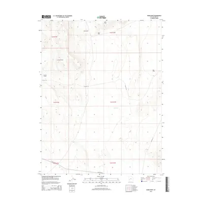
2014 Map of Warm Point
USGS Topo · Published 2014About this map
Confusion Range defines the western reaches of this Millard County landscape, where the high desert terrain transitions into several distinct geological formations. This 2014 survey captures a sparsely populated region of the Great Basin, dominated by wide basins like Tule Valley and the northern slopes of the Barn Hills. The map traces a network of remote corridors including Snake Pass Rd and Ibex Well Rd, which provide access to landforms such as Smooth Canyon and the secluded Blind Valley. Water features are exceptionally rare in this arid environment, represented primarily by the seasonal Sand Wash and the eponymous Warm Point. The grid of the Public Land Survey System is clearly marked across the terrain, indicating the township and range boundaries that govern this expansive portion of western Utah.
Find a feature on this map
16 named features on this map. Tap any name to fly to it.
Don’t see what you’re looking for? This feature index may not catch every label — zoom into the map to look around manually.
Map Details
Editions of this 2014 Warm Point Map
This is the sole edition of this map. No revisions or reprints were ever made.
Other maps of this area

1953 · Richfield
USGS Topo · 1:250,000

1958 · Richfield
USGS Topo · 1:250,000

1960 · Frisco Peak
USGS Topo · 1:62,500

1960 · Wah Wah Summit
USGS Topo · 1:62,500

1960 · Crystal Peak
USGS Topo · 1:62,500

1960 · The Barn
USGS Topo · 1:62,500

1980 · Wah Wah Mts. North
USGS Topo · 1:100,000
1989 · Brown Knoll
USGS Topo · 1:24,000
1989 · Fifteenmile Point
USGS Topo · 1:24,000
1989 · Grassy Cove
USGS Topo · 1:24,000