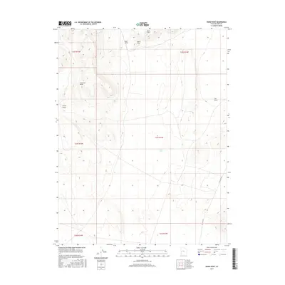
2017 Map of Warm Point
USGS Topo · Published 2017About this map
The Confusion Range dominates the western portion of this Great Basin landscape in Millard County, providing a stark topographical contrast to the broad basins nearby. In the northeast, the Barn Hills and the prominent Warm Point overlook Blind Valley, a landform that illustrates the complex drainage and elevation patterns of the region. This 2017 survey shows a largely undeveloped expanse where natural features define the geography rather than human settlements. To the east, the wide Tule Valley is accessed by the lonely Tule Valley Rd, which serves as the primary corridor through the desert floor. Occasional drainage features like Sand Wash and the incision of Smooth Canyon reveal the erosional forces at work on these carbonate mountains, which have long been of interest to geologists and backcountry explorers for their Paleozoic stratigraphic record.
Find a feature on this map
14 named features on this map. Tap any name to fly to it.
Don’t see what you’re looking for? This feature index may not catch every label — zoom into the map to look around manually.
Map Details
Editions of this 2017 Warm Point Map
This is the sole edition of this map. No revisions or reprints were ever made.
Other maps of this area

1953 · Richfield
USGS Topo · 1:250,000

1958 · Richfield
USGS Topo · 1:250,000

1960 · Frisco Peak
USGS Topo · 1:62,500

1960 · Wah Wah Summit
USGS Topo · 1:62,500

1960 · Crystal Peak
USGS Topo · 1:62,500

1960 · The Barn
USGS Topo · 1:62,500

1980 · Wah Wah Mts. North
USGS Topo · 1:100,000
1989 · Brown Knoll
USGS Topo · 1:24,000
1989 · Fifteenmile Point
USGS Topo · 1:24,000
1989 · Grassy Cove
USGS Topo · 1:24,000