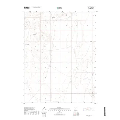
2020 Map of Warm Point
USGS Topo · Published 2020About this map
The Confusion Range dominates the western edge of this Great Basin landscape, characterized by dramatic elevation changes and desert drainage patterns. To the north, the Barn Hills and the prominent Warm Point overlook Blind Valley, while the eastern portion of the sheet transitions into the expansive Tule Valley. The topography is defined by ephemeral features like the Sand Wash, which cuts across the central flats between the mountain ranges. Human presence is sparse, marked primarily by the Tule Valley Rd navigating the eastern basin. This 2020 survey illustrates a region where geology and landform remain the primary features, showcasing the complex relationship between the high ridges of Smooth Canyon and the dry valley floors below.
Find a feature on this map
8 named features on this map. Tap any name to fly to it.
Don’t see what you’re looking for? This feature index may not catch every label — zoom into the map to look around manually.
Map Details
Editions of this 2020 Warm Point Map
This is the sole edition of this map. No revisions or reprints were ever made.
Other maps of this area

1953 · Richfield
USGS Topo · 1:250,000

1958 · Richfield
USGS Topo · 1:250,000

1960 · Frisco Peak
USGS Topo · 1:62,500

1960 · Wah Wah Summit
USGS Topo · 1:62,500

1960 · Crystal Peak
USGS Topo · 1:62,500

1960 · The Barn
USGS Topo · 1:62,500

1980 · Wah Wah Mts. North
USGS Topo · 1:100,000
1989 · Brown Knoll
USGS Topo · 1:24,000
1989 · Fifteenmile Point
USGS Topo · 1:24,000
1989 · Grassy Cove
USGS Topo · 1:24,000